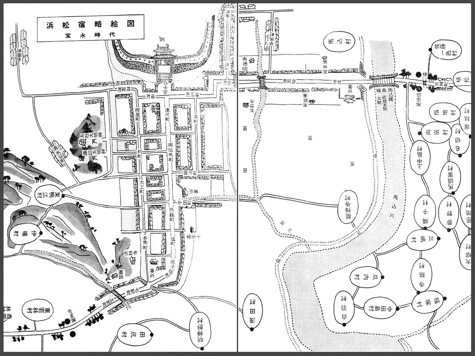
Hamamatsu-juku
[Route]
| Address | Naka-ku, Hamamatsu-shi |
|---|---|
| Time | Edo period |
Overview
The Hamamatsu-juku was one of the 53 stations of the Tokaido Road, which was a main artery from Edo to Kyoto/Osaka, where were Japan's center of politics in the Early Modern Age. It was the 29th station from Edo and the 25th from Kyoto. Located midway between the cities, the castle town of the Hamamatsu clan had 6 honjin, inns for government officials, and 94 hatago, inns for travelers, in the Tenpo period (1830-1844).
Layout
People entered the Hamamatsu-juku from Shin-machi after they crossed the bridge over the Makome River, then proceeded to Itaya-cho, Ta-machi, and Shinmei-cho. They would arrive at in front of the gate of the Hamamatsu castle after walking up a hill in Shinmei. The road then turned left, people would proceed to Renjaku-cho, Tenma-cho, Hatago-machi, Shio-machi, and Narukozaka-cho, then turned to right and there were Nanaken-cho. Bansho, guardhouse, were built in three locations; the east bansho at the Magome bridge, the west in Narukozaka, and the middle bansho in Tenma-cho. Kosatsuba, public announcements board, was placed in Renjaku-cho. Having many transport businesses, the streets of Tenma-cho and Tonya-cho, located nearby the middle bansho, were boisterous. The system of sukego, which obligated peasants to supply post stations labors and horses, was initiated in 1637. Iba-mura, Higashikamoe-mura, Nishiwakabayashi-mura, and Sato-mura were appointed to fulfill the duty.
Reputaion
"Dochuki", a road map and guide published in 1659, evaluates all Tokaido's stations. Hamamatsu-juku was rated the highest on three point scale. Ihara Saikaku's note in 1689 states that it was a prosperous station with long streets. "Kaigen Kiko", the travel journal by Ota Nanpo, depicts the town in 1801 in minute detail. Moreover, Hiroshige remembers his stay in the Hamamatsu-juku in 1830 in his note that the castle town was genuinely flourished.
Map